Make a donation
Gear up for your next adventure:
As an Amazon Associate, this site earns from qualifying purchases at no extra cost to you.
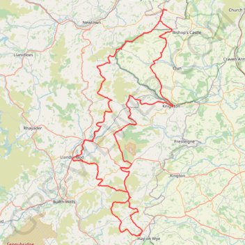
Mid wales again
- Distance: 203.7 Km
- Elevation gain: 4,902 m
- Maximum elevation: 545 m
- Elevation loss: 4,901 m
- Minimum elevation: 94 m
- Moving time: 6 h 36 s
- Moving speed: 33.9 Km/h
- Maximum speed: 79.6 Km/h
- Total time: 8 h 56 m
- Global speed: 22.8 Km/h
Interactive trail map
Make a donation
Gear up for your next adventure:
As an Amazon Associate, this site earns from qualifying purchases at no extra cost to you.
Trail profile
- Distance: 203.7 Km
- Elevation gain: 4,902 m
- Maximum elevation: 545 m
- Elevation loss: 4,901 m
- Minimum elevation: 94 m
- Moving time: 6 h 36 s
- Moving speed: 33.9 Km/h
- Maximum speed: 79.6 Km/h
- Total time: 8 h 56 m
- Global speed: 22.8 Km/h
Make a donation
Gear up for your next adventure:
As an Amazon Associate, this site earns from qualifying purchases at no extra cost to you.
About this trail
Name: Mid wales again trail, distance, elevation, map, profile, GPS track
Start: Freerein Riding Holidays, A438, Clyro, Powys, Wales, HR3 5LE, United Kingdom (52.07946 -3.15511)
End: Freerein Riding Holidays, A438, Clyro, Powys, Wales, HR3 5LE, United Kingdom (52.07942 -3.15531)
Coordinates: 52.07911 -3.38037 52.53990 -3.04289
Make a donation
Gear up for your next adventure:
As an Amazon Associate, this site earns from qualifying purchases at no extra cost to you.
Other hiking, mountain biking, running and outdoor activity trails
Click on a trail to view its statistics, map and profile.
The Headstock 500
United Kingdom > Wales > Newport > Newport
Distance: 483.5 Km • Elevation gain: 9,616 m • Maximum elevation: 691 m
Knighton circular walk on public foot paths
United Kingdom > Wales > Powys > Knighton
Distance: 14.7 Km • Elevation gain: 396 m • Maximum elevation: 413 m
Hergest Ridge and Hergest Croft Gardens
United Kingdom > England > Herefordshire > Kington
Distance: 12.5 Km • Elevation gain: 351 m • Maximum elevation: 415 m
Bishops Castle to Clun
United Kingdom > England > Shropshire > Bishop's Castle
Distance: 20.7 Km • Elevation gain: 606 m • Maximum elevation: 403 m
Make a donation
Gear up for your next adventure:
As an Amazon Associate, this site earns from qualifying purchases at no extra cost to you.
Cusop Hill
United Kingdom > England > Herefordshire > Cusop
Distance: 15.2 Km • Elevation gain: 388 m • Maximum elevation: 394 m
Clyro
United Kingdom > England > Herefordshire > Cusop
Distance: 12.7 Km • Elevation gain: 289 m • Maximum elevation: 229 m