Thank you for supporting this site ❤️
Make a donation
Make a donation
Gear up for your next adventure:
As an Amazon Associate, this site earns from qualifying purchases at no extra cost to you.
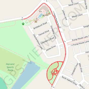
Trace along center of footpaths, Harvest Sports Park
- Distance: 2.4 Km
- Elevation gain: 7 m
- Maximum elevation: 107 m
- Elevation loss: 8 m
- Minimum elevation: 99 m
- Moving time: 28 m 49 s
- Moving speed: 5.1 Km/h
- Maximum speed: 14.1 Km/h
- Total time: 28 m 49 s
- Global speed: 5.1 Km/h
Interactive trail map
Thank you for supporting this site ❤️
Make a donation
Make a donation
Gear up for your next adventure:
As an Amazon Associate, this site earns from qualifying purchases at no extra cost to you.
Trail profile
- Distance: 2.4 Km
- Elevation gain: 7 m
- Maximum elevation: 107 m
- Elevation loss: 8 m
- Minimum elevation: 99 m
- Moving time: 28 m 49 s
- Moving speed: 5.1 Km/h
- Maximum speed: 14.1 Km/h
- Total time: 28 m 49 s
- Global speed: 5.1 Km/h
Thank you for supporting this site ❤️
Make a donation
Make a donation
Gear up for your next adventure:
As an Amazon Associate, this site earns from qualifying purchases at no extra cost to you.
About this trail
Name: Trace along center of footpaths, Harvest Sports Park trail, distance, elevation, map, profile, GPS track
Coordinates: 34.36294 -119.04724 34.36723 -119.04457
Thank you for supporting this site ❤️
Make a donation
Make a donation
Gear up for your next adventure:
As an Amazon Associate, this site earns from qualifying purchases at no extra cost to you.