Thank you for supporting this site ❤️
Make a donation
Make a donation
Gear up for your next adventure:
As an Amazon Associate, this site earns from qualifying purchases at no extra cost to you.
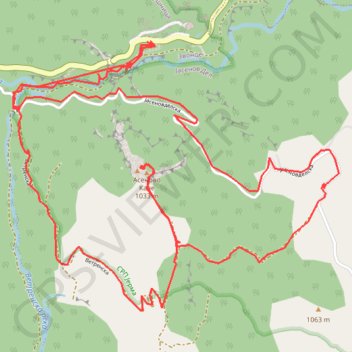
Asenovo Kale loop hike
- Distance: 9.6 Km
- Elevation gain: 510 m
- Maximum elevation: 985 m
- Elevation loss: 510 m
- Minimum elevation: 611 m
- Moving time: 3 h 55 m
- Moving speed: 2.5 Km/h
- Maximum speed: 15.6 Km/h
- Total time: 4 h 16 m
- Global speed: 2.3 Km/h
Interactive trail map
Thank you for supporting this site ❤️
Make a donation
Make a donation
Gear up for your next adventure:
As an Amazon Associate, this site earns from qualifying purchases at no extra cost to you.
Trail profile
- Distance: 9.6 Km
- Elevation gain: 510 m
- Maximum elevation: 985 m
- Elevation loss: 510 m
- Minimum elevation: 611 m
- Moving time: 3 h 55 m
- Moving speed: 2.5 Km/h
- Maximum speed: 15.6 Km/h
- Total time: 4 h 16 m
- Global speed: 2.3 Km/h
Thank you for supporting this site ❤️
Make a donation
Make a donation
Gear up for your next adventure:
As an Amazon Associate, this site earns from qualifying purchases at no extra cost to you.
About this trail
Name: Asenovo Kale loop hike trail, distance, elevation, map, profile, GPS track
Coordinates: 42.91978 22.59287 42.93230 22.61357
Thank you for supporting this site ❤️
Make a donation
Make a donation
Gear up for your next adventure:
As an Amazon Associate, this site earns from qualifying purchases at no extra cost to you.