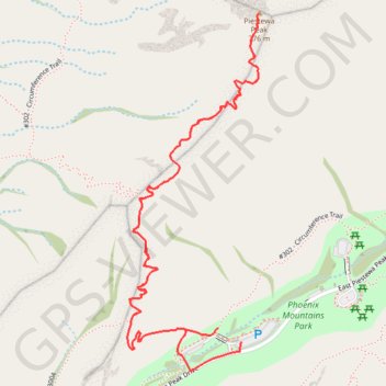
Piestewa Peak Summit Trail in Phoenix Mountains Preserve
The Piestewa Peak Summit Trail offers hikers a challenging and rewarding journey to one of the most iconic viewpoints in the Phoenix area. As you ascend, you’ll encounter a mix of steep rock steps, narrow stairways, and a few scrambles, making the hike both physically demanding and invigorating. At the summit, the views are expansive, revealing a 360-degree panorama of downtown Phoenix, Camelback Mountain, and the surrounding desert ranges, providing a stunning backdrop that makes the effort worthwhile. #Hiking #Mountain #Overlook #City #Nature
- Distance: 3.9 Km
- Elevation gain: 324 m
- Maximum elevation: 758 m
- Elevation loss: 325 m
- Minimum elevation: 434 m
Interactive trail map
Trail profile
- Distance: 3.9 Km
- Elevation gain: 324 m
- Maximum elevation: 758 m
- Elevation loss: 325 m
- Minimum elevation: 434 m
About this trail
Name: Piestewa Peak Summit Trail in Phoenix Mountains Preserve trail, distance, elevation, map, profile, GPS track
Coordinates: 33.53901 -112.02488 33.54763 -112.02109
Other hiking, mountain biking, running and outdoor activity trails
Click on a trail to view its statistics, map and profile.
Piestewa Peak via Summit Trail in Phoenix Mountain Preserve
United States > Arizona > Maricopa County > Phoenix
Summit Trail to Piestewa Peak offers a challenging yet rewarding climb with fantastic views of the Sonoran Desert and the surrounding cityscape. The well-marked path makes it easy to navigate, and the occasional shaded spots provide a welcome break from the sun as you make your way to the summit. #Hiking…
Distance: 3.5 Km • Elevation gain: 318 m • Maximum elevation: 758 m
Freedom/Circumference Loop Trail in Phoenix Mountain Preserve
United States > Arizona > Maricopa County > Phoenix
The Freedom/Circumference Loop Trail in the Phoenix Mountain Preserve offers a rewarding journey around Piestewa Peak, showcasing sweeping views of the surrounding desert and cityscape. Hikers are treated to rugged Sonoran Desert landscapes, with saguaro cacti and vibrant wildflowers dotting the trail, as well…
Distance: 5.8 Km • Elevation gain: 352 m • Maximum elevation: 640 m