Thank you for supporting this site ❤️
Make a donation
Make a donation
Gear up for your next adventure:
As an Amazon Associate, this site earns from qualifying purchases at no extra cost to you.
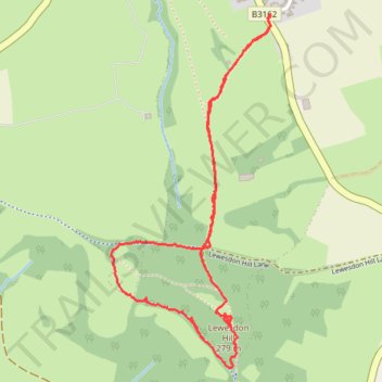
Lewesdon loop walk
- Distance: 3.8 Km
- Elevation gain: 128 m
- Maximum elevation: 270 m
- Elevation loss: 128 m
- Minimum elevation: 175 m
- Moving time: 1 h 16 m
- Moving speed: 3.0 Km/h
- Maximum speed: 6.6 Km/h
- Total time: 1 h 54 m
- Global speed: 2.0 Km/h
Interactive trail map
Thank you for supporting this site ❤️
Make a donation
Make a donation
Gear up for your next adventure:
As an Amazon Associate, this site earns from qualifying purchases at no extra cost to you.
Trail profile
- Distance: 3.8 Km
- Elevation gain: 128 m
- Maximum elevation: 270 m
- Elevation loss: 128 m
- Minimum elevation: 175 m
- Moving time: 1 h 16 m
- Moving speed: 3.0 Km/h
- Maximum speed: 6.6 Km/h
- Total time: 1 h 54 m
- Global speed: 2.0 Km/h
Thank you for supporting this site ❤️
Make a donation
Make a donation
Gear up for your next adventure:
As an Amazon Associate, this site earns from qualifying purchases at no extra cost to you.
About this trail
Name: Lewesdon loop walk trail, distance, elevation, map, profile, GPS track
Start: 2, Redlands Lane, Broadwindsor, Dorset, England, DT8 3ST, United Kingdom (50.81717 -2.79733)
End: 2, Redlands Lane, Broadwindsor, Dorset, England, DT8 3ST, United Kingdom (50.81710 -2.79735)
Coordinates: 50.80600 -2.80532 50.81717 -2.79733
Thank you for supporting this site ❤️
Make a donation
Make a donation
Gear up for your next adventure:
As an Amazon Associate, this site earns from qualifying purchases at no extra cost to you.