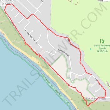
St Andrews Beach and Ocean Drive sunset walk in Mornington Peninsula National Park
- Distance: 4.9 Km
- Elevation gain: 66 m
- Maximum elevation: 35 m
- Elevation loss: 62 m
- Minimum elevation: 6 m
- Moving time: 56 m 2 s
- Moving speed: 5.3 Km/h
- Maximum speed: 9.0 Km/h
- Total time: 58 m 25 s
- Global speed: 5.1 Km/h
Interactive trail map
Trail profile
- Distance: 4.9 Km
- Elevation gain: 66 m
- Maximum elevation: 35 m
- Elevation loss: 62 m
- Minimum elevation: 6 m
- Moving time: 56 m 2 s
- Moving speed: 5.3 Km/h
- Maximum speed: 9.0 Km/h
- Total time: 58 m 25 s
- Global speed: 5.1 Km/h
About this trail
Name: St Andrews Beach and Ocean Drive sunset walk in Mornington Peninsula National Park trail, distance, elevation, map, profile, GPS track
Coordinates: -38.43450 144.83106 -38.42032 144.84899
Topography: Melbourne topographic map, elevation, terrain
Other hiking, mountain biking, running and outdoor activity trails
Click on a trail to view its statistics, map and profile.
St Andrews Beach, Boag rocks, Gunnamatta beach, Cape Schanck walk
Australia > Victoria > Melbourne
Distance: 12.7 Km • Elevation gain: 263 m • Maximum elevation: 122 m