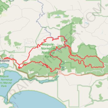
Walpole-Nornalup National Park MTB Loop
- Distance: 64.5 Km
- Elevation gain: 1,200 m
- Maximum elevation: 204 m
- Elevation loss: 1,198 m
- Minimum elevation: 4 m
- Moving time: 5 h 17 m
- Moving speed: 12.2 Km/h
- Maximum speed: 46.9 Km/h
- Total time: 6 h 32 m
- Global speed: 9.9 Km/h
Interactive trail map
Trail profile
- Distance: 64.5 Km
- Elevation gain: 1,200 m
- Maximum elevation: 204 m
- Elevation loss: 1,198 m
- Minimum elevation: 4 m
- Moving time: 5 h 17 m
- Moving speed: 12.2 Km/h
- Maximum speed: 46.9 Km/h
- Total time: 6 h 32 m
- Global speed: 9.9 Km/h
About this trail
Name: Walpole-Nornalup National Park MTB Loop trail, distance, elevation, map, profile, GPS track
Coordinates: -34.99207 116.73106 -34.94763 116.88247
Topography: Western Australia topographic map, elevation, terrain