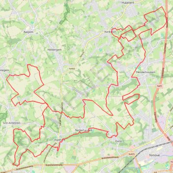
55km
Total: 51.4km
- Distance: 51.3 Km
- Elevation gain: 363 m
- Maximum elevation: 82 m
- Elevation loss: 363 m
- Minimum elevation: 16 m
Interactive trail map
Trail profile
- Distance: 51.3 Km
- Elevation gain: 363 m
- Maximum elevation: 82 m
- Elevation loss: 363 m
- Minimum elevation: 16 m
About this trail
Name: 55km trail, distance, elevation, map, profile, GPS track
Coordinates: 50.83040 3.92155 50.90036 4.03267
Other hiking, mountain biking, running and outdoor activity trails
Click on a trail to view its statistics, map and profile.
SDB-Moerzeke-60k
Belgium > East Flanders > Oudenaarde > Zwalm > Sint-Denijs-Boekel
name=SDB-Moerzeke-60k
Distance: 60.9 Km • Elevation gain: 229 m • Maximum elevation: 60 m
GOTOES Export
Belgium > East Flanders > Oudenaarde > Zwalm > Sint-Denijs-Boekel
Created with GOTOES STRAVA TOOLS Version 23.9
Distance: 63.9 Km • Elevation gain: 362 m • Maximum elevation: 85 m
Iedereen 1000 KOTK OVL noordlus 131km met Iben en Jana (eindresultaat deze wk 469km gefietst, 23K gelopen en 12K gewandeld)
Belgium > East Flanders > Gent > Heusden
Distance: 130.2 Km • Elevation gain: 579 m • Maximum elevation: 81 m
SDB-Moerzeke 46K
Belgium > East Flanders > Oudenaarde > Zwalm > Sint-Denijs-Boekel
name=SDB-Moerzeke 46K
Distance: 46.7 Km • Elevation gain: 172 m • Maximum elevation: 70 m
Zwalm-Puyenbroeck-68k
Belgium > East Flanders > Oudenaarde > Zwalm > Sint-Denijs-Boekel
name=Zwalm-Puyenbroeck-68k
Distance: 68.3 Km • Elevation gain: 248 m • Maximum elevation: 54 m
SDB-Work 32K
Belgium > East Flanders > Oudenaarde > Zwalm > Sint-Denijs-Boekel
name=SDB-Work 32K
Distance: 32.0 Km • Elevation gain: 180 m • Maximum elevation: 85 m