Trails near Root River
Afternoon Run
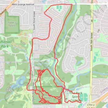
- Distance: 16.3 Km
- Elevation gain: 199 m
- Maximum elevation: 266 m
- Elevation loss: 199 m
- Minimum elevation: 213 m
- Moving time: 1 h 54 m
- Moving speed: 8.5 Km/h
- Maximum speed: 14.5 Km/h
- Total time: 1 h 54 m
- Global speed: 8.5 Km/h
Interactive trail map
Trail profile
- Distance: 16.3 Km
- Elevation gain: 199 m
- Maximum elevation: 266 m
- Elevation loss: 199 m
- Minimum elevation: 213 m
- Moving time: 1 h 54 m
- Moving speed: 8.5 Km/h
- Maximum speed: 14.5 Km/h
- Total time: 1 h 54 m
- Global speed: 8.5 Km/h
About this trail
Name: Trails near Root River trail, distance, elevation, map, profile, GPS track
Coordinates: 42.91981 -88.03081 42.94480 -88.01230