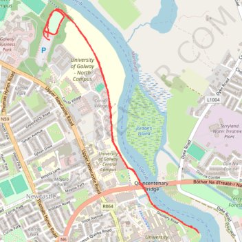
University Of Galway parkrun jog/walk
- Distance: 5.7 Km
- Elevation gain: 14 m
- Maximum elevation: 11 m
- Elevation loss: 14 m
- Minimum elevation: 3 m
- Moving time: 44 m 19 s
- Moving speed: 7.8 Km/h
- Maximum speed: 29.1 Km/h
- Total time: 44 m 19 s
- Global speed: 7.8 Km/h
Interactive trail map
Trail profile
- Distance: 5.7 Km
- Elevation gain: 14 m
- Maximum elevation: 11 m
- Elevation loss: 14 m
- Minimum elevation: 3 m
- Moving time: 44 m 19 s
- Moving speed: 7.8 Km/h
- Maximum speed: 29.1 Km/h
- Total time: 44 m 19 s
- Global speed: 7.8 Km/h
About this trail
Name: University Of Galway parkrun jog/walk trail, distance, elevation, map, profile, GPS track
Coordinates: 53.27992 -9.07110 53.29286 -9.05607