Cassidy Arch Trail
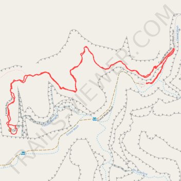
Interactive trail map
Trail profile
- Distance: 5.3 Km
- Elevation gain: 296 m
- Maximum elevation: 1,824 m
- Elevation loss: 296 m
- Minimum elevation: 1,653 m
- Moving time: 1 h 7 m
- Moving speed: 4.7 Km/h
- Maximum speed: 10.9 Km/h
- Total time: 1 h 8 m
- Global speed: 4.6 Km/h
About this trail
Name: Cassidy Arch Trail trail, distance, elevation, map, profile, GPS track
Start: Grand Wash Trail, Wayne County, Utah, United States (38.26379 -111.21556)
End: Grand Wash Trail, Wayne County, Utah, United States (38.26381 -111.21556)
Coordinates: 38.26072 -111.22621 38.26601 -111.21340
Other hiking, mountain biking, running and outdoor activity trails
Click on a trail to view its statistics, map and profile.
Cassidy Arch Trail in Capitol Reef National Park
United States > Utah > Wayne County
The Cassidy Arch Trail in Capitol Reef National Park offers hikers panoramic views of the Utah desert landscape, including towering sandstone cliffs and expansive canyon vistas. Along the path, one can observe the expansive Waterpocket Fold, a remarkable wrinkle in the Earth's crust, and the rugged Grand Wash,…
Distance: 5.1 Km • Elevation gain: 300 m • Maximum elevation: 1,823 m