Bembridge old railway track
- Distance: 2.4 Km
- Elevation gain: 8 m
- Maximum elevation: 2 m
- Elevation loss: 7 m
- Minimum elevation: -2 m
- Moving time: 25 m 15 s
- Moving speed: 5.7 Km/h
- Maximum speed: 8.4 Km/h
- Total time: 26 m 2 s
- Global speed: 5.5 Km/h
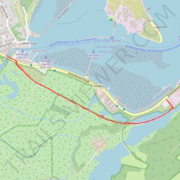
Interactive trail map
Trail profile
- Distance: 2.4 Km
- Elevation gain: 8 m
- Maximum elevation: 2 m
- Elevation loss: 7 m
- Minimum elevation: -2 m
- Moving time: 25 m 15 s
- Moving speed: 5.7 Km/h
- Maximum speed: 8.4 Km/h
- Total time: 26 m 2 s
- Global speed: 5.5 Km/h
About this trail
Name: Bembridge old railway track trail, distance, elevation, map, profile, GPS track
Start: Embankment Road, Bembridge, Isle of Wight, England, PO33 1XG, United Kingdom (50.69329 -1.10875)
End: Embankment Road, St. Helens, Isle of Wight, England, PO33 1YS, United Kingdom (50.69343 -1.10924)
Coordinates: 50.68983 -1.10924 50.69343 -1.09526