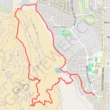
Summerin south mesa ridge explore
- Distance: 12.0 Km
- Elevation gain: 334 m
- Maximum elevation: 1,040 m
- Elevation loss: 338 m
- Minimum elevation: 822 m
- Moving time: 2 h 36 m
- Moving speed: 4.6 Km/h
- Maximum speed: 6.8 Km/h
- Total time: 2 h 37 m
- Global speed: 4.6 Km/h
Interactive trail map
Trail profile
- Distance: 12.0 Km
- Elevation gain: 334 m
- Maximum elevation: 1,040 m
- Elevation loss: 338 m
- Minimum elevation: 822 m
- Moving time: 2 h 36 m
- Moving speed: 4.6 Km/h
- Maximum speed: 6.8 Km/h
- Total time: 2 h 37 m
- Global speed: 4.6 Km/h
About this trail
Name: Summerin south mesa ridge explore trail, distance, elevation, map, profile, GPS track
Coordinates: 36.07130 -115.34331 36.09728 -115.31794
Other hiking, mountain biking, running and outdoor activity trails
Click on a trail to view its statistics, map and profile.
Mesa Brown Canyon Loop
United States > Nevada > Clark County > Summerlin South
Distance: 10.7 Km • Elevation gain: 226 m • Maximum elevation: 1,089 m