East Branch and West Branch Brisbane River
Interactive trail map
Trail profile
- Distance: 52.7 Km
- Elevation gain: 877 m
- Maximum elevation: 541 m
- Elevation loss: 878 m
- Minimum elevation: 170 m
About this trail
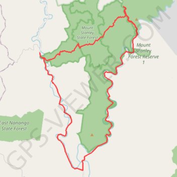
Name: East Branch and West Branch Brisbane River trail, distance, elevation, map, profile, GPS track
Start: Eastern Branch Road, Mount Stanley, Somerset Regional, Queensland, Australia (-26.67372 152.20146)
End: Eastern Branch Road, Mount Stanley, Somerset Regional, Queensland, Australia (-26.67344 152.20162)
Coordinates: -26.67501 152.16492 -26.55082 152.24774
Topography: Queensland topographic map, elevation, terrain
Other hiking, mountain biking, running and outdoor activity trails
Click on a trail to view its statistics, map and profile.
Nanango - Brisbane River
Nanango State Forest. Mount Stanley State Forest. #MTB #Nanango #MountStanley
Distance: 52.2 Km • Elevation gain: 1,004 m • Maximum elevation: 546 m