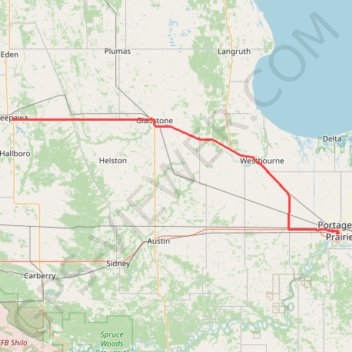
Neepawa - Portage la Prairie
#Bike #Neepawa #PortageLaPrairie
- Distance: 101.0 Km
- Elevation gain: 77 m
- Maximum elevation: 355 m
- Elevation loss: 166 m
- Minimum elevation: 253 m
Interactive trail map
Trail profile
- Distance: 101.0 Km
- Elevation gain: 77 m
- Maximum elevation: 355 m
- Elevation loss: 166 m
- Minimum elevation: 253 m
About this trail
Name: Neepawa - Portage la Prairie trail, distance, elevation, map, profile, GPS track
Start: Neepawa, Manitoba, R0J 1H0, Canada (50.22918 -99.45494)
End: Parish Lot, Portage la Prairie, Manitoba, R1N 0M8, Canada (49.96571 -98.29936)
Coordinates: 49.96487 -99.45494 50.22918 -98.29060
Other hiking, mountain biking, running and outdoor activity trails
Click on a trail to view its statistics, map and profile.
Sidney - Portage la Prairie
Canada > Municipality of North Norfolk > Sidney
#Bike #Sidney #PortageLaPrairie
Distance: 59.1 Km • Elevation gain: 39 m • Maximum elevation: 379 m