Import a GPX file

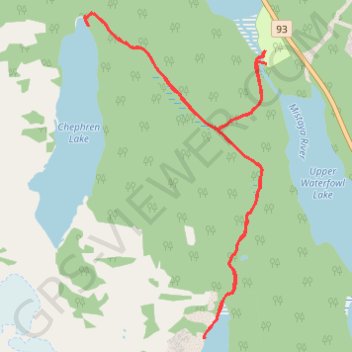
Cirque Lake - Chephren Lake

Banff National Park. #Hiking #Cirque #Chephren #Banff

  • Distance: 13.7 Km
  • Elevation gain: 356 m
  • Maximum elevation: 1,817 m
  • Elevation loss: 354 m
  • Minimum elevation: 1,661 m

Interactive trail map

Trail profile

  • Distance: 13.7 Km
  • Elevation gain: 356 m
  • Maximum elevation: 1,817 m
  • Elevation loss: 354 m
  • Minimum elevation: 1,661 m

About this trail

Other hiking, mountain biking, running and outdoor activity trails

Click on a trail to view its statistics, map and profile.

Jasper National Park - Banff National Park

Canada > Alberta > Improvement District No. 12

#Bike #Jasper #Banff

Distance: 84.1 Km • Elevation gain: 1,174 m • Maximum elevation: 2,070 m

Banff National Park - Lake Louise

Canada > Alberta > Improvement District No. 9

#Bike #Banff

Distance: 61.8 Km • Elevation gain: 601 m • Maximum elevation: 2,038 m

Gear up for your next adventure:

🍳Ultralight Camping Stoves - Boil water quickly for meals using minimal fuel
🔦LED Torches - LED torches for outdoor use
🔋Solar Power Banks - Charge your phone and GPS using the sun while deep in the bush
🏫Topographic World Globes - 3D physical relief globes to understand global geography
👕UPF 50+ Sun Shirts - Essential protection against the harsh Australian sun during field work

As an Amazon Associate, this site earns from qualifying purchases at no extra cost to you.