Hike in the Royal National Park
- Distance: 14.0 Km
- Elevation gain: 354 m
- Maximum elevation: 163 m
- Elevation loss: 388 m
- Minimum elevation: 1 m
- Moving time: 3 h 12 m
- Moving speed: 4.4 Km/h
- Maximum speed: 10.3 Km/h
- Total time: 3 h 53 m
- Global speed: 3.6 Km/h
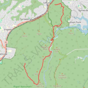
Interactive trail map
Trail profile
- Distance: 14.0 Km
- Elevation gain: 354 m
- Maximum elevation: 163 m
- Elevation loss: 388 m
- Minimum elevation: 1 m
- Moving time: 3 h 12 m
- Moving speed: 4.4 Km/h
- Maximum speed: 10.3 Km/h
- Total time: 3 h 53 m
- Global speed: 3.6 Km/h
About this trail
Name: Hike in the Royal National Park trail, distance, elevation, map, profile, GPS track
End: Karloo Track, Sutherland Shire Council, New South Wales, 2233, Australia (-34.09212 151.02971)
Coordinates: -34.10965 151.02866 -34.04397 151.06789
Topography: New South Wales topographic map, elevation, terrain
Other hiking, mountain biking, running and outdoor activity trails
Click on a trail to view its statistics, map and profile.
Bicycle ride from Maroubra to Loftus
Australia > New South Wales > Sydney
Distance: 33.8 Km • Elevation gain: 276 m • Maximum elevation: 112 m