Woodland Fort paths
- Distance: 5.3 Km
- Elevation gain: 97 m
- Maximum elevation: 82 m
- Elevation loss: 47 m
- Minimum elevation: 11 m
- Moving time: 58 m 58 s
- Moving speed: 5.3 Km/h
- Maximum speed: 46.9 Km/h
- Total time: 1 h 11 m
- Global speed: 4.4 Km/h
Interactive trail map
Trail profile
- Distance: 5.3 Km
- Elevation gain: 97 m
- Maximum elevation: 82 m
- Elevation loss: 47 m
- Minimum elevation: 11 m
- Moving time: 58 m 58 s
- Moving speed: 5.3 Km/h
- Maximum speed: 46.9 Km/h
- Total time: 1 h 11 m
- Global speed: 4.4 Km/h
About this trail
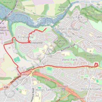
Name: Woodland Fort paths trail, distance, elevation, map, profile, GPS track
Coordinates: 50.41147 -4.18761 50.42186 -4.15349
Other hiking, mountain biking, running and outdoor activity trails
Click on a trail to view its statistics, map and profile.
Woodland Woods
United Kingdom > England > Plymouth
Distance: 2.9 Km • Elevation gain: 71 m • Maximum elevation: 80 m
Budshead wood
United Kingdom > England > Plymouth
Distance: 4.3 Km • Elevation gain: 50 m • Maximum elevation: 34 m
Budshead Wood
United Kingdom > England > Plymouth
Distance: 2.9 Km • Elevation gain: 67 m • Maximum elevation: 56 m
Budshead wood
United Kingdom > England > Plymouth
Distance: 1.3 Km • Elevation gain: 31 m • Maximum elevation: 68 m
Budshead Wood
United Kingdom > England > Plymouth
Distance: 1.1 Km • Elevation gain: 9 m • Maximum elevation: 63 m