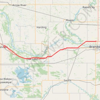
Import a GPX file

Virden - Brandon

#Bike #Virden #Brandon

  • Distance: 79.7 Km
  • Elevation gain: 137 m
  • Maximum elevation: 446 m
  • Elevation loss: 172 m
  • Minimum elevation: 367 m

Interactive trail map

Trail profile

  • Distance: 79.7 Km
  • Elevation gain: 137 m
  • Maximum elevation: 446 m
  • Elevation loss: 172 m
  • Minimum elevation: 367 m

About this trail

Other hiking, mountain biking, running and outdoor activity trails

Click on a trail to view its statistics, map and profile.

Moosomin - Virden

Canada > Saskatchewan > Moosomin No. 121 > Moosomin

#Bike #Moosomin #Virden

Distance: 68.7 Km • Elevation gain: 34 m • Maximum elevation: 577 m

Brandon - Sidney

Canada > Rural Municipality of Elton > Brandon

#Bike #Brandon #Sidney

Distance: 66.4 Km • Elevation gain: 104 m • Maximum elevation: 407 m

Gear up for your next adventure:

📣High-Decibel Survival Whistles - Signaling tool for rescue that carries much further than a human voice
📍Handheld GPS - GPS devices for hiking and navigation
🔦Headlamps - Hands-free lighting for hiking
🧴Sunscreen SPF - Sun protection for outdoor activities
🎽Hiking Clothing - Breathable clothing for hiking

As an Amazon Associate, this site earns from qualifying purchases at no extra cost to you.