Make a donation
Gear up for your next adventure:
As an Amazon Associate, this site earns from qualifying purchases at no extra cost to you.
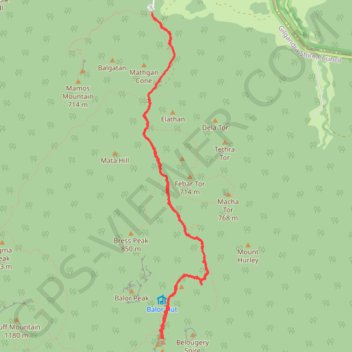
Breadknife - Grand High Tops Track
Warrumbungle National Park. #Hiking #Warrumbungle
- Distance: 10.8 Km
- Elevation gain: 424 m
- Maximum elevation: 900 m
- Elevation loss: 423 m
- Minimum elevation: 503 m
- Moving time: 2 h 37 m
- Moving speed: 4.1 Km/h
- Maximum speed: 15.8 Km/h
- Total time: 3 h 38 m
- Global speed: 3.0 Km/h
Interactive trail map
Make a donation
Gear up for your next adventure:
As an Amazon Associate, this site earns from qualifying purchases at no extra cost to you.
Trail profile
- Distance: 10.8 Km
- Elevation gain: 424 m
- Maximum elevation: 900 m
- Elevation loss: 423 m
- Minimum elevation: 503 m
- Moving time: 2 h 37 m
- Moving speed: 4.1 Km/h
- Maximum speed: 15.8 Km/h
- Total time: 3 h 38 m
- Global speed: 3.0 Km/h
Make a donation
Gear up for your next adventure:
As an Amazon Associate, this site earns from qualifying purchases at no extra cost to you.
About this trail
Name: Breadknife - Grand High Tops Track trail, distance, elevation, map, profile, GPS track
Start: Fans Horizon trail, Gilgandra Shire Council, New South Wales, Australia (-31.29639 148.99464)
End: Grand High Tops Track, Gilgandra Shire Council, New South Wales, Australia (-31.29656 148.99461)
Coordinates: -31.33124 148.99363 -31.29639 149.00170
Topography: New South Wales topographic map, elevation, terrain
Make a donation
Gear up for your next adventure:
As an Amazon Associate, this site earns from qualifying purchases at no extra cost to you.