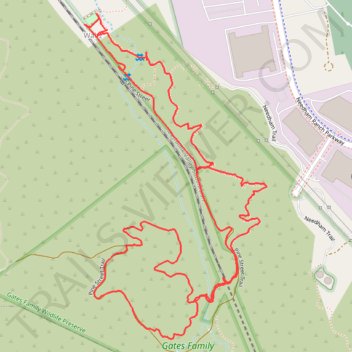
Pine Street Trail and Brady Trail Loop in Gates Family Wildlife Preserve
- Distance: 4.9 Km
- Elevation gain: 128 m
- Maximum elevation: 527 m
- Elevation loss: 128 m
- Minimum elevation: 434 m
- Moving time: 1 h 3 m
- Moving speed: 4.7 Km/h
- Maximum speed: 14.5 Km/h
- Total time: 1 h 7 m
- Global speed: 4.3 Km/h
Interactive trail map
Trail profile
- Distance: 4.9 Km
- Elevation gain: 128 m
- Maximum elevation: 527 m
- Elevation loss: 128 m
- Minimum elevation: 434 m
- Moving time: 1 h 3 m
- Moving speed: 4.7 Km/h
- Maximum speed: 14.5 Km/h
- Total time: 1 h 7 m
- Global speed: 4.3 Km/h
About this trail
Name: Pine Street Trail and Brady Trail Loop in Gates Family Wildlife Preserve trail, distance, elevation, map, profile, GPS track
Coordinates: 34.35153 -118.52176 34.36091 -118.51536
Other hiking, mountain biking, running and outdoor activity trails
Click on a trail to view its statistics, map and profile.
Pioneer Trail Loop Hike
United States > California > Los Angeles County > Santa Clarita > Elayon
Distance: 5.0 Km • Elevation gain: 93 m • Maximum elevation: 457 m