Thank you for supporting this site ❤️
Make a donation
Make a donation
Gear up for your next adventure:
As an Amazon Associate, this site earns from qualifying purchases at no extra cost to you.
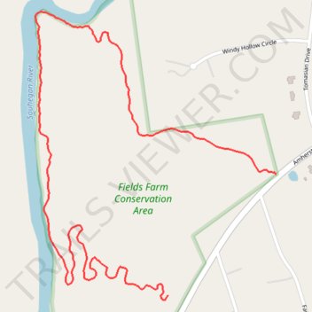
Fields Farm Conservation Area Trails
- Distance: 2.5 Km
- Elevation gain: 33 m
- Maximum elevation: 97 m
- Elevation loss: 37 m
- Minimum elevation: 62 m
- Moving time: 14 m 26 s
- Moving speed: 10.5 Km/h
- Maximum speed: 22.1 Km/h
- Total time: 16 m 30 s
- Global speed: 9.2 Km/h
Interactive trail map
Thank you for supporting this site ❤️
Make a donation
Make a donation
Gear up for your next adventure:
As an Amazon Associate, this site earns from qualifying purchases at no extra cost to you.
Trail profile
- Distance: 2.5 Km
- Elevation gain: 33 m
- Maximum elevation: 97 m
- Elevation loss: 37 m
- Minimum elevation: 62 m
- Moving time: 14 m 26 s
- Moving speed: 10.5 Km/h
- Maximum speed: 22.1 Km/h
- Total time: 16 m 30 s
- Global speed: 9.2 Km/h
Thank you for supporting this site ❤️
Make a donation
Make a donation
Gear up for your next adventure:
As an Amazon Associate, this site earns from qualifying purchases at no extra cost to you.
About this trail
Name: Fields Farm Conservation Area Trails trail, distance, elevation, map, profile, GPS track
Coordinates: 42.84107 -71.55866 42.84795 -71.55084
Thank you for supporting this site ❤️
Make a donation
Make a donation
Gear up for your next adventure:
As an Amazon Associate, this site earns from qualifying purchases at no extra cost to you.
Other hiking, mountain biking, running and outdoor activity trails
Click on a trail to view its statistics, map and profile.
Fields Farms Conservation Area Trails
United States > New Hampshire > Hillsborough County > Merrimack
Distance: 11.0 Km • Elevation gain: 126 m • Maximum elevation: 100 m