Eagle Creek and Falls
Hike from Columbia River to the Wahtum Lake along Eagle Creek via Metlako Falls, Sorenson Falls, Punch Bowl Falls, Four Mile Falls, Wy east Falls, Grand Union Falls, Tunnel Falls and Twister Falls in the Mark O. Hatfield Wilderness. #Hiking #River #Falls #Canyon #Forest #Mountain #Lake #Wilderness
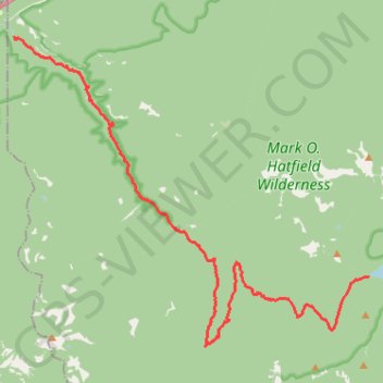
- Distance: 21.1 Km
- Elevation gain: 1,778 m
- Maximum elevation: 1,144 m
- Elevation loss: 681 m
- Minimum elevation: 42 m
Interactive trail map
Trail profile
- Distance: 21.1 Km
- Elevation gain: 1,778 m
- Maximum elevation: 1,144 m
- Elevation loss: 681 m
- Minimum elevation: 42 m
About this trail
Name: Eagle Creek and Falls trail, distance, elevation, map, profile, GPS track
End: Chindere Cutoff Trail #406M, Hood River County, Oregon, United States (45.58111 -121.80109)
Coordinates: 45.56448 -121.91966 45.63727 -121.80097
Other hiking, mountain biking, running and outdoor activity trails
Click on a trail to view its statistics, map and profile.
Tunnel Falls via Eagle Creek Trail in Columbia River Gorge National Scenic Area
United States > Oregon > Hood River County
The Eagle Creek Trail to Tunnel Falls offers hikers a captivating journey through the Columbia River Gorge, showcasing a series of stunning waterfalls, including the iconic Tunnel Falls, where the trail passes behind a 172-foot cascade. Along the way, hikers encounter diverse landscapes, from lush forests to…
Distance: 19.4 Km • Elevation gain: 1,057 m • Maximum elevation: 407 m
Punchbowl Falls via Eagle Creek in Columbia River Gorge National Scenic Area
United States > Oregon > Multnomah County
The Eagle Creek Trail to Punchbowl Falls offers hikers a journey through lush old-growth forests, with the trail meandering alongside the clear waters of Eagle Creek. Along the way, you'll encounter several cascading waterfalls, including the impressive Punchbowl Falls, where water plunges into a large,…
Distance: 8.2 Km • Elevation gain: 543 m • Maximum elevation: 193 m
Punchbowl Falls via Eagle Creek Trail in Columbia River Gorge National Scenic Area
United States > Oregon > Multnomah County
The hike to Punchbowl Falls via the Eagle Creek Trail offers a beautiful and immersive experience among lush forests and dramatic landscapes. Along the route, hikers can enjoy breathtaking views of cascading waterfalls, such as Metlako Falls and Twister Falls, while navigating sections of the trail that follow…
Distance: 9.0 Km • Elevation gain: 615 m • Maximum elevation: 195 m
Northern part of the Pacific Crest Trail (PCT)
United States > Oregon > Klamath County
Hike on the Pacific Crest National Scenic Trail from Crater Lake to Canada Border through Oregon and Washington along the Sierra Nevada and Cascade mountain ranges. #Hiking #Mountain #SierraNevada #Cascade #Nature #Forest #Park #PCT
Distance: 1,198.3 Km • Elevation gain: 44,308 m • Maximum elevation: 2,307 m
Expedition to Sedum Ridge
United States > Oregon > Multnomah County > Portland
Distance: 214.7 Km • Elevation gain: 5,093 m • Maximum elevation: 1,169 m