Thank you for supporting this site ❤️
Make a donation
Make a donation
Gear up for your next adventure:
As an Amazon Associate, this site earns from qualifying purchases at no extra cost to you.
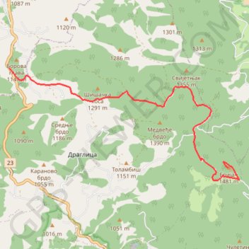
Murternica trek
- Distance: 10.2 Km
- Elevation gain: 488 m
- Maximum elevation: 1,467 m
- Elevation loss: 93 m
- Minimum elevation: 1,071 m
Interactive trail map
Thank you for supporting this site ❤️
Make a donation
Make a donation
Gear up for your next adventure:
As an Amazon Associate, this site earns from qualifying purchases at no extra cost to you.
Trail profile
- Distance: 10.2 Km
- Elevation gain: 488 m
- Maximum elevation: 1,467 m
- Elevation loss: 93 m
- Minimum elevation: 1,071 m
Thank you for supporting this site ❤️
Make a donation
Make a donation
Gear up for your next adventure:
As an Amazon Associate, this site earns from qualifying purchases at no extra cost to you.
About this trail
Name: Murternica trek trail, distance, elevation, map, profile, GPS track
Coordinates: 43.58694 19.72516 43.61186 19.79562
Thank you for supporting this site ❤️
Make a donation
Make a donation
Gear up for your next adventure:
As an Amazon Associate, this site earns from qualifying purchases at no extra cost to you.
Other hiking, mountain biking, running and outdoor activity trails
Click on a trail to view its statistics, map and profile.
2022_Yu
Slovenia > Ajdovščina > Žapuže
Distance: 2,457.3 Km • Elevation gain: 32,048 m • Maximum elevation: 1,950 m