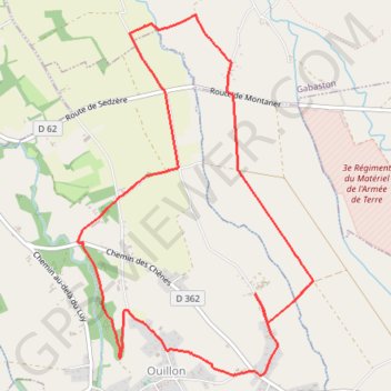
La randonnée du berger d'Ouillon
Interactive trail map
Trail profile
- Distance: 9.3 Km
- Elevation gain: 49 m
- Maximum elevation: 331 m
- Elevation loss: 49 m
- Minimum elevation: 301 m
About this trail
Name: La randonnée du berger d'Ouillon trail, distance, elevation, map, profile, GPS track
Coordinates: 43.32091 -0.23436 43.34642 -0.21158
Other hiking, mountain biking, running and outdoor activity trails
Click on a trail to view its statistics, map and profile.
GR 10 - Traversée des Pyrénées
France > Occitania > Pyrénées-Orientales > Banyuls-sur-Mer
Distance: 874.8 Km • Elevation gain: 57,000 m • Maximum elevation: 2,599 m
Southern section — European Divide Trail
France > Auvergne-Rhône-Alpes > Drôme > Valence
Distance: 2,423.8 Km • Elevation gain: 42,375 m • Maximum elevation: 2,005 m
1 LUCENA - MONTPELLIER
Distance: 2,964.4 Km • Elevation gain: 29,500 m • Maximum elevation: 1,048 m
Chemin de Saint-Jacques-de-Compostelle
Switzerland > Geneva > Geneva
Distance: 1,117.8 Km • Elevation gain: 25,262 m • Maximum elevation: 1,430 m