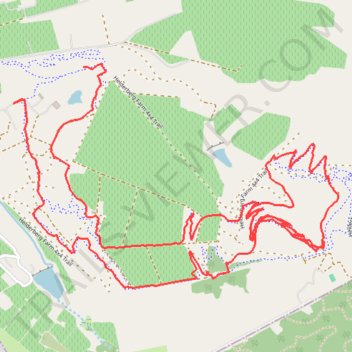
Helderberg Ride
- Distance: 11.6 Km
- Elevation gain: 404 m
- Maximum elevation: 447 m
- Elevation loss: 438 m
- Minimum elevation: 163 m
- Moving time: 1 h 6 m
- Moving speed: 10.5 Km/h
- Maximum speed: 45.3 Km/h
- Total time: 1 h 8 m
- Global speed: 10.2 Km/h
Interactive trail map
Trail profile
- Distance: 11.6 Km
- Elevation gain: 404 m
- Maximum elevation: 447 m
- Elevation loss: 438 m
- Minimum elevation: 163 m
- Moving time: 1 h 6 m
- Moving speed: 10.5 Km/h
- Maximum speed: 45.3 Km/h
- Total time: 1 h 8 m
- Global speed: 10.2 Km/h
About this trail
Name: Helderberg Ride trail, distance, elevation, map, profile, GPS track
Coordinates: -34.04169 18.83483 -34.03052 18.85435