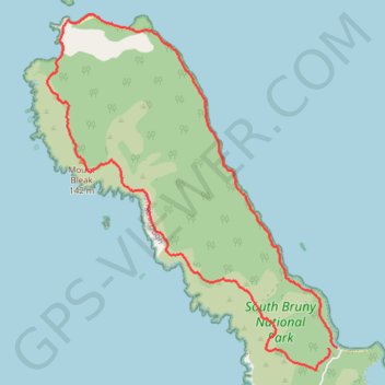
Labillardiere Penninsula Circuit - South Bruny National Park
- Distance: 17.7 Km
- Elevation gain: 420 m
- Maximum elevation: 133 m
- Elevation loss: 441 m
- Minimum elevation: -1 m
- Moving time: 2 h 1 m
- Moving speed: 8.7 Km/h
- Maximum speed: 60.4 Km/h
- Total time: 2 h 3 m
- Global speed: 8.6 Km/h
Interactive trail map
Trail profile
- Distance: 17.7 Km
- Elevation gain: 420 m
- Maximum elevation: 133 m
- Elevation loss: 441 m
- Minimum elevation: -1 m
- Moving time: 2 h 1 m
- Moving speed: 8.7 Km/h
- Maximum speed: 60.4 Km/h
- Total time: 2 h 3 m
- Global speed: 8.6 Km/h
About this trail
Name: Labillardiere Penninsula Circuit - South Bruny National Park trail, distance, elevation, map, profile, GPS track
Start: Jetty Beach Access, South Bruny, Kingborough, Tasmania, 7150, Australia (-43.45901 147.15197)
End: Jetty Beach Access, South Bruny, Kingborough, Tasmania, 7150, Australia (-43.45894 147.15370)
Coordinates: -43.46213 147.09620 -43.41100 147.15370
Topography: Tasmania topographic map, elevation, terrain