Import a GPX file

York Water District (YWD) loop

  • Distance: 15.4 Km
  • Elevation gain: 148 m
  • Maximum elevation: 99 m
  • Elevation loss: 156 m
  • Minimum elevation: 48 m

Interactive trail map

Trail profile

  • Distance: 15.4 Km
  • Elevation gain: 148 m
  • Maximum elevation: 99 m
  • Elevation loss: 156 m
  • Minimum elevation: 48 m

About this trail
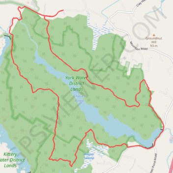
Name: York Water District (YWD) loop trail, distance, elevation, map, profile, GPS track

Start: 350, Mountain Road, Agamenticus Village, York, York County, Maine, 03902, United States (43.21396 -70.67958)

End: 335, Mountain Road, Agamenticus Village, York, York County, Maine, 03902, United States (43.21522 -70.67629)

Coordinates: 43.18439 -70.69096 43.21590 -70.64924

Gear up for your next adventure:

🔋Rechargeable Batteries - Eco-friendly power for high-drain GPS units and flashlights
🌿Flora and Fauna Field Guides - Identify the plants and animals you encounter on your route
🦟Insect Repellent - Protection against insects
🎧Bluetooth Outdoor Earbuds - Listen to navigation cues or podcasts during long solo treks
🎨Portable Watercolor Kits - Paint the landscapes and topographic views you discover

As an Amazon Associate, this site earns from qualifying purchases at no extra cost to you.