Import a GPX file

Bertha Falls - Bertha Lake

Waterton Lakes National Park. #Hiking #Loop #Bertha #WatertonLakes
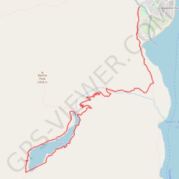
  • Distance: 10.4 Km
  • Elevation gain: 211 m
  • Maximum elevation: 1,800 m
  • Elevation loss: 678 m
  • Minimum elevation: 1,294 m

Interactive trail map

Trail profile

  • Distance: 10.4 Km
  • Elevation gain: 211 m
  • Maximum elevation: 1,800 m
  • Elevation loss: 678 m
  • Minimum elevation: 1,294 m

About this trail

Name: Bertha Falls - Bertha Lake trail, distance, elevation, map, profile, GPS track

Start: Bertha Lake, Improvement District No. 04, Alberta, Canada (49.02992 -113.93545)

End: Evergreen Avenue, Waterton Park, Improvement District No. 04, Alberta, T0K 2M0, Canada (49.05119 -113.91628)

Coordinates: 49.01858 -113.95054 49.05119 -113.91212

Gear up for your next adventure:

🏃Compression Recovery Socks - Reduce leg fatigue after heavy days of elevation gain
🐍Snake Gaiters - Protection against snake bites
🕶️Polarized Outdoor Sunglasses - Reduce glare from rocks and water for better visual navigation
👕UPF 50+ Sun Shirts - Essential protection against the harsh Australian sun during field work
🔥Windproof Plasma Lighters - USB rechargeable lighters that work in high-altitude winds

As an Amazon Associate, this site earns from qualifying purchases at no extra cost to you.