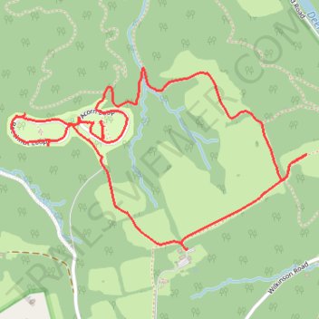
Susquehanna State Park Campground trails
- Distance: 4.7 Km
- Elevation gain: 66 m
- Maximum elevation: 105 m
- Elevation loss: 66 m
- Minimum elevation: 60 m
- Moving time: 1 h 36 m
- Moving speed: 2.9 Km/h
- Maximum speed: 4.6 Km/h
- Total time: 1 h 57 m
- Global speed: 2.4 Km/h
Interactive trail map
Trail profile
- Distance: 4.7 Km
- Elevation gain: 66 m
- Maximum elevation: 105 m
- Elevation loss: 66 m
- Minimum elevation: 60 m
- Moving time: 1 h 36 m
- Moving speed: 2.9 Km/h
- Maximum speed: 4.6 Km/h
- Total time: 1 h 57 m
- Global speed: 2.4 Km/h
About this trail
Name: Susquehanna State Park Campground trails trail, distance, elevation, map, profile, GPS track
Start: Ivy Branch Trail (orange), Harford County, Maryland, 21094, United States (39.60756 -76.15930)
End: Ivy Branch Trail (orange), Harford County, Maryland, 21094, United States (39.60752 -76.15932)
Coordinates: 39.60752 -76.16816 39.61458 -76.15329