Import a GPX file

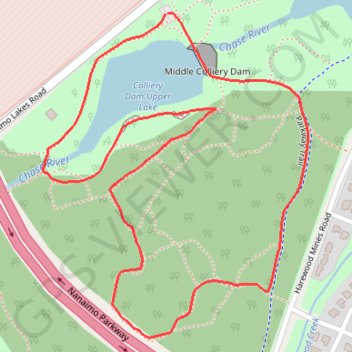
Colliery Dam Park Loop

Vancouver Island. #Hiking #Running #Loop #Vancouver

  • Distance: 2.2 Km
  • Elevation gain: 54 m
  • Maximum elevation: 132 m
  • Elevation loss: 54 m
  • Minimum elevation: 91 m

Interactive trail map

Trail profile

  • Distance: 2.2 Km
  • Elevation gain: 54 m
  • Maximum elevation: 132 m
  • Elevation loss: 54 m
  • Minimum elevation: 91 m

About this trail

Gear up for your next adventure:

💧Personal Water Filters - Drink safely from streams and lakes identified on your map
🔥Camping Stoves - Portable stoves for outdoor cooking
🧺Waterproof Dry Sacks - Organize your pack and keep electronics safe from rain and river crossings
📣High-Decibel Survival Whistles - Signaling tool for rescue that carries much further than a human voice
🎒Tactical Waist Packs - Quick access to your compass, phone, and snacks while walking

As an Amazon Associate, this site earns from qualifying purchases at no extra cost to you.