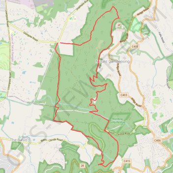
Glasgow - Doongalla
Interactive trail map
Trail profile
- Distance: 14.7 Km
- Elevation gain: 792 m
- Maximum elevation: 591 m
- Elevation loss: 786 m
- Minimum elevation: 187 m
About this trail
Name: Glasgow - Doongalla trail, distance, elevation, map, profile, GPS track
Coordinates: -37.86236 145.33241 -37.82259 145.35315
Topography: Melbourne topographic map, elevation, terrain
Other hiking, mountain biking, running and outdoor activity trails
Click on a trail to view its statistics, map and profile.
Upper Ferntree Gully
Australia > Victoria > Melbourne
Upftg ride
Distance: 44.0 Km • Elevation gain: 1,583 m • Maximum elevation: 529 m
Dandenong Ranges National Park Ridgewalk
Australia > Victoria > Melbourne > Tremont
Distance: 22.1 Km • Elevation gain: 1,002 m • Maximum elevation: 591 m
Kero Tin - One Tree Hill New Track
Australia > Victoria > Melbourne
Distance: 12.4 Km • Elevation gain: 465 m • Maximum elevation: 554 m
Ferny Creek ride
Australia > Victoria > Melbourne
Distance: 36.9 Km • Elevation gain: 960 m • Maximum elevation: 531 m
Morning MTB ride
Australia > Victoria > Melbourne
Morning Mountain Bike Ride
Distance: 35.8 Km • Elevation gain: 1,406 m • Maximum elevation: 549 m