Thank you for supporting this site ❤️
Make a donation
Make a donation
Gear up for your next adventure:
As an Amazon Associate, this site earns from qualifying purchases at no extra cost to you.
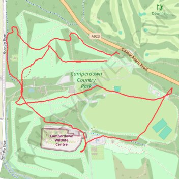
Camperdown Park
- Distance: 5.8 Km
- Elevation gain: 99 m
- Maximum elevation: 156 m
- Elevation loss: 104 m
- Minimum elevation: 90 m
- Moving time: 52 m
- Moving speed: 6.7 Km/h
- Maximum speed: 15.8 Km/h
- Total time: 52 m
- Global speed: 6.7 Km/h
Interactive trail map
Thank you for supporting this site ❤️
Make a donation
Make a donation
Gear up for your next adventure:
As an Amazon Associate, this site earns from qualifying purchases at no extra cost to you.
Trail profile
- Distance: 5.8 Km
- Elevation gain: 99 m
- Maximum elevation: 156 m
- Elevation loss: 104 m
- Minimum elevation: 90 m
- Moving time: 52 m
- Moving speed: 6.7 Km/h
- Maximum speed: 15.8 Km/h
- Total time: 52 m
- Global speed: 6.7 Km/h
Thank you for supporting this site ❤️
Make a donation
Make a donation
Gear up for your next adventure:
🧊Insulated Stainless Steel Flasks - Keep water cold for 24 hours in the heat or coffee hot in the cold
As an Amazon Associate, this site earns from qualifying purchases at no extra cost to you.
About this trail
Name: Camperdown Park trail, distance, elevation, map, profile, GPS track
Coordinates: 56.48039 -3.05061 56.48872 -3.03066
Thank you for supporting this site ❤️
Make a donation
Make a donation
Gear up for your next adventure:
As an Amazon Associate, this site earns from qualifying purchases at no extra cost to you.
Other hiking, mountain biking, running and outdoor activity trails
Click on a trail to view its statistics, map and profile.
Camperdown parkrun
United Kingdom > Scotland > Dundee City > Dundee
Distance: 4.9 Km • Elevation gain: 92 m • Maximum elevation: 129 m