Thank you for supporting this site ❤️
Make a donation
Make a donation
Gear up for your next adventure:
As an Amazon Associate, this site earns from qualifying purchases at no extra cost to you.
Warrnambool
Interactive trail map
Thank you for supporting this site ❤️
Make a donation
Make a donation
Gear up for your next adventure:
As an Amazon Associate, this site earns from qualifying purchases at no extra cost to you.
Trail profile
- Distance: 10.1 Km
- Elevation gain: 57 m
- Maximum elevation: 8 m
- Elevation loss: 56 m
- Minimum elevation: 1 m
Thank you for supporting this site ❤️
Make a donation
Make a donation
Gear up for your next adventure:
As an Amazon Associate, this site earns from qualifying purchases at no extra cost to you.
About this trail
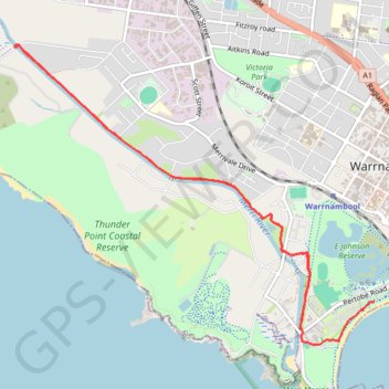
Name: Warrnambool trail, distance, elevation, map, profile, GPS track
End: Pertobe Road, Warrnambool, City of Warrnambool, Victoria, 3280, Australia (-38.39401 142.47988)
Coordinates: -38.39765 142.44135 -38.37248 142.47988
Topography: Warrnambool topographic map, elevation, terrain
Thank you for supporting this site ❤️
Make a donation
Make a donation
Gear up for your next adventure:
As an Amazon Associate, this site earns from qualifying purchases at no extra cost to you.