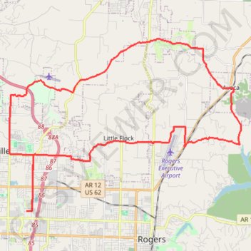
Import a GPX file

Bentonville - Avoca

#Bike #Loop

  • Distance: 41.4 Km
  • Elevation gain: 413 m
  • Maximum elevation: 416 m
  • Elevation loss: 412 m
  • Minimum elevation: 332 m

Interactive trail map

Trail profile

  • Distance: 41.4 Km
  • Elevation gain: 413 m
  • Maximum elevation: 416 m
  • Elevation loss: 412 m
  • Minimum elevation: 332 m

About this trail

Gear up for your next adventure:

🛌Sleeping Mats - Insulated mats for camping comfort
🧊Insulated Cooler Bags - Keep food fresh for day trips to remote geographic sites
🔦Powerful LED Headlamps - Hands-free lighting for night navigation and setting up camp after dark
👖Convertible Hiking Trousers - Zip-off legs to adapt to changing temperatures throughout the day
Altimeter Watches - Watches with altitude tracking

As an Amazon Associate, this site earns from qualifying purchases at no extra cost to you.