Thank you for supporting this site ❤️
Make a donation
Make a donation
Gear up for your next adventure:
As an Amazon Associate, this site earns from qualifying purchases at no extra cost to you.
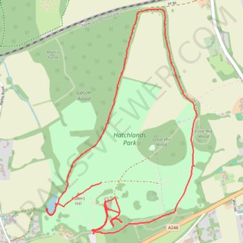
2026-05-25 HATCHLANDS NT
- Distance: 5.9 Km
- Elevation gain: 64 m
- Maximum elevation: 96 m
- Elevation loss: 55 m
- Minimum elevation: 57 m
- Moving time: 1 h 30 m
- Moving speed: 3.9 Km/h
- Maximum speed: 8.0 Km/h
- Total time: 2 h 53 m
- Global speed: 2.1 Km/h
Interactive trail map
Thank you for supporting this site ❤️
Make a donation
Make a donation
Gear up for your next adventure:
🛰️Handheld GPS Units - Rugged GPS devices for tracking coordinates and elevation in the Australian bush
As an Amazon Associate, this site earns from qualifying purchases at no extra cost to you.
Trail profile
- Distance: 5.9 Km
- Elevation gain: 64 m
- Maximum elevation: 96 m
- Elevation loss: 55 m
- Minimum elevation: 57 m
- Moving time: 1 h 30 m
- Moving speed: 3.9 Km/h
- Maximum speed: 8.0 Km/h
- Total time: 2 h 53 m
- Global speed: 2.1 Km/h
Thank you for supporting this site ❤️
Make a donation
Make a donation
Gear up for your next adventure:
As an Amazon Associate, this site earns from qualifying purchases at no extra cost to you.
About this trail
Name: 2026-05-25 HATCHLANDS NT trail, distance, elevation, map, profile, GPS track
Start: A246, West Horsley, Guildford, Surrey, England, KT24 6EA, United Kingdom (51.25887 -0.47269)
Coordinates: 51.25570 -0.47813 51.26959 -0.46329
Thank you for supporting this site ❤️
Make a donation
Make a donation
Gear up for your next adventure:
As an Amazon Associate, this site earns from qualifying purchases at no extra cost to you.