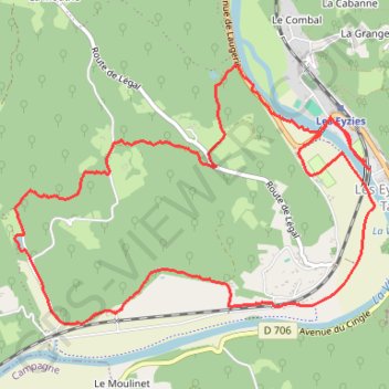
Les Eyzies Boucle Gorge d'enfer
- Distance: 9.7 Km
- Elevation gain: 211 m
- Maximum elevation: 161 m
- Elevation loss: 211 m
- Minimum elevation: 58 m
Interactive trail map
Trail profile
- Distance: 9.7 Km
- Elevation gain: 211 m
- Maximum elevation: 161 m
- Elevation loss: 211 m
- Minimum elevation: 58 m
About this trail
Name: Les Eyzies Boucle Gorge d'enfer trail, distance, elevation, map, profile, GPS track
Coordinates: 44.92815 0.98048 44.94375 1.01107
Other hiking, mountain biking, running and outdoor activity trails
Click on a trail to view its statistics, map and profile.
GR®652 Voie de Rocamadour (2021)
France > Auvergne-Rhône-Alpes > Cantal > Laroquebrou > Messac
Randonnée sur le GR®652 Voie de Rocamadour vers Saint-Jacques-de-Compostelle à travers le Cantal, le Lot, le Lot-et-Garonne et le Gers de Laroquebrou à La Romieu. Gîtes d'étapes, Chambres d'hôtes, Maison d'hôtes, Hôtels, Camping, Refuges, Auberges, Commerces.
Distance: 336.6 Km • Elevation gain: 9,067 m • Maximum elevation: 540 m
Southern section — European Divide Trail
France > Auvergne-Rhône-Alpes > Drôme > Valence
Distance: 2,423.8 Km • Elevation gain: 42,375 m • Maximum elevation: 2,005 m
Chemin de Saint-Jacques-de-Compostelle
Switzerland > Geneva > Geneva
Distance: 1,117.8 Km • Elevation gain: 25,262 m • Maximum elevation: 1,430 m
GR 654 - Le chemin vers Saint-Jacques-de-Compostelle via Vézelay
France > Nouvelle-Aquitaine > Dordogne > Bergerac
Distance: 810.9 Km • Elevation gain: 9,631 m • Maximum elevation: 670 m