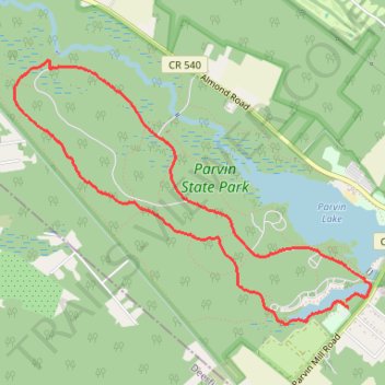
Parvin State Park Forest Road and Long Trail Loop
- Distance: 7.3 Km
- Elevation gain: 34 m
- Maximum elevation: 31 m
- Elevation loss: 35 m
- Minimum elevation: 19 m
- Moving time: 53 m 38 s
- Moving speed: 8.2 Km/h
- Maximum speed: 10.7 Km/h
- Total time: 53 m 38 s
- Global speed: 8.2 Km/h
Interactive trail map
Trail profile
- Distance: 7.3 Km
- Elevation gain: 34 m
- Maximum elevation: 31 m
- Elevation loss: 35 m
- Minimum elevation: 19 m
- Moving time: 53 m 38 s
- Moving speed: 8.2 Km/h
- Maximum speed: 10.7 Km/h
- Total time: 53 m 38 s
- Global speed: 8.2 Km/h
About this trail
Name: Parvin State Park Forest Road and Long Trail Loop trail, distance, elevation, map, profile, GPS track
Coordinates: 39.50166 -75.16156 39.51904 -75.13114