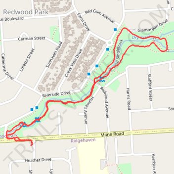
Sherwood Reserve
- Distance: 2.4 Km
- Elevation gain: 23 m
- Maximum elevation: 169 m
- Elevation loss: 23 m
- Minimum elevation: 148 m
- Moving time: 39 m 30 s
- Moving speed: 3.6 Km/h
- Maximum speed: 5.8 Km/h
- Total time: 42 m 27 s
- Global speed: 3.4 Km/h
Interactive trail map
Trail profile
- Distance: 2.4 Km
- Elevation gain: 23 m
- Maximum elevation: 169 m
- Elevation loss: 23 m
- Minimum elevation: 148 m
- Moving time: 39 m 30 s
- Moving speed: 3.6 Km/h
- Maximum speed: 5.8 Km/h
- Total time: 42 m 27 s
- Global speed: 3.4 Km/h
About this trail
Name: Sherwood Reserve trail, distance, elevation, map, profile, GPS track
Coordinates: -34.81681 138.70604 -34.81219 138.71373
Topography: Adelaide topographic map, elevation, terrain
Other hiking, mountain biking, running and outdoor activity trails
Click on a trail to view its statistics, map and profile.
Dry Creek to the Triangle
Australia > South Australia > Adelaide
Distance: 21.3 Km • Elevation gain: 174 m • Maximum elevation: 204 m
Dry Creek Trail
Australia > South Australia > Adelaide
Distance: 22.5 Km • Elevation gain: 263 m • Maximum elevation: 204 m