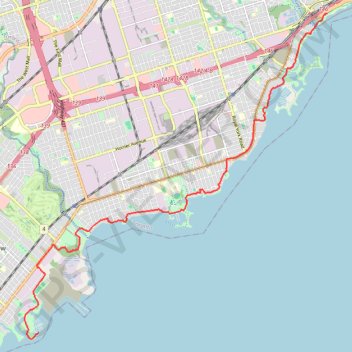
Toronto - Martin Goodman Trail - Waterfront Trail
Interactive trail map
Trail profile
- Distance: 15.0 Km
- Elevation gain: 74 m
- Maximum elevation: 87 m
- Elevation loss: 78 m
- Minimum elevation: 73 m
About this trail
Name: Toronto - Martin Goodman Trail - Waterfront Trail trail, distance, elevation, map, profile, GPS track
Coordinates: 43.56248 -79.56028 43.63457 -79.46785
Other hiking, mountain biking, running and outdoor activity trails
Click on a trail to view its statistics, map and profile.
Old mills to humber bay park
Distance: 12.4 Km • Elevation gain: 75 m • Maximum elevation: 96 m
Brampton - Scarborough
Canada > Ontario > Peel Region > Brampton
Lake Ontario. #Bike #Brampton #Scarborough #Toronto #Ontario
Distance: 73.2 Km • Elevation gain: 570 m • Maximum elevation: 184 m
Hamilton - Toronto
#Bike
Distance: 81.3 Km • Elevation gain: 458 m • Maximum elevation: 111 m
Toronto Cycling
Distance: 39.0 Km • Elevation gain: 356 m • Maximum elevation: 124 m