Thank you for supporting this site ❤️
Make a donation
Make a donation
Gear up for your next adventure:
As an Amazon Associate, this site earns from qualifying purchases at no extra cost to you.
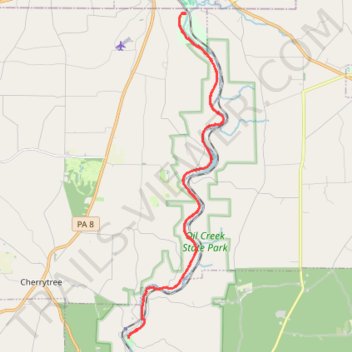
Oil Creek Trail to Petroleum Center
- Distance: 31.1 Km
- Elevation gain: 444 m
- Maximum elevation: 385 m
- Elevation loss: 444 m
- Minimum elevation: 323 m
- Moving time: 1 h 42 m
- Moving speed: 18.1 Km/h
- Maximum speed: 42.9 Km/h
- Total time: 1 h 51 m
- Global speed: 16.7 Km/h
Interactive trail map
Thank you for supporting this site ❤️
Make a donation
Make a donation
Gear up for your next adventure:
As an Amazon Associate, this site earns from qualifying purchases at no extra cost to you.
Trail profile
- Distance: 31.1 Km
- Elevation gain: 444 m
- Maximum elevation: 385 m
- Elevation loss: 444 m
- Minimum elevation: 323 m
- Moving time: 1 h 42 m
- Moving speed: 18.1 Km/h
- Maximum speed: 42.9 Km/h
- Total time: 1 h 51 m
- Global speed: 16.7 Km/h
Thank you for supporting this site ❤️
Make a donation
Make a donation
Gear up for your next adventure:
As an Amazon Associate, this site earns from qualifying purchases at no extra cost to you.
About this trail
Name: Oil Creek Trail to Petroleum Center trail, distance, elevation, map, profile, GPS track
Coordinates: 41.51537 -79.68230 41.61578 -79.64274
Thank you for supporting this site ❤️
Make a donation
Make a donation
Gear up for your next adventure:
As an Amazon Associate, this site earns from qualifying purchases at no extra cost to you.