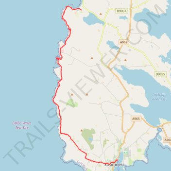
Hike from Skara Brae to Stromness
- Distance: 16.3 Km
- Elevation gain: 415 m
- Maximum elevation: 111 m
- Elevation loss: 425 m
- Minimum elevation: 0 m
- Moving time: 3 h 50 m
- Moving speed: 4.2 Km/h
- Maximum speed: 16.6 Km/h
- Total time: 4 h 28 m
- Global speed: 3.6 Km/h
Interactive trail map
Trail profile
- Distance: 16.3 Km
- Elevation gain: 415 m
- Maximum elevation: 111 m
- Elevation loss: 425 m
- Minimum elevation: 0 m
- Moving time: 3 h 50 m
- Moving speed: 4.2 Km/h
- Maximum speed: 16.6 Km/h
- Total time: 4 h 28 m
- Global speed: 3.6 Km/h
About this trail
Name: Hike from Skara Brae to Stromness trail, distance, elevation, map, profile, GPS track
Start: B9056, Orkney Islands, Scotland, KW16 3LR, United Kingdom (59.04876 -3.33559)
Coordinates: 58.96136 -3.36671 59.05074 -3.29567
Other hiking, mountain biking, running and outdoor activity trails
Click on a trail to view its statistics, map and profile.
Yesnaby to North Gaulton Castle
United Kingdom > Scotland > Orkney Islands
Distance: 8.1 Km • Elevation gain: 340 m • Maximum elevation: 58 m