Saddleback via Phoneline Trail and Blackett's Ridge Trail in Pusch Ridge Wilderness
Hiking to Saddleback offers a rugged adventure amidst the stunning desert landscape of Tucson, Arizona. Along the route, hikers are treated to expansive views of Sabino Canyon and Bear Canyon, with striking features like towering saguaro cacti, prickly pear, and diverse birdlife. The challenging ascents through varied terrain provide an opportunity to experience both the natural beauty and solitude of this wilderness area, making it a rewarding yet demanding trek for those seeking both physical challenge and scenic rewards. #Hiking #Mountain #Desert #Nature
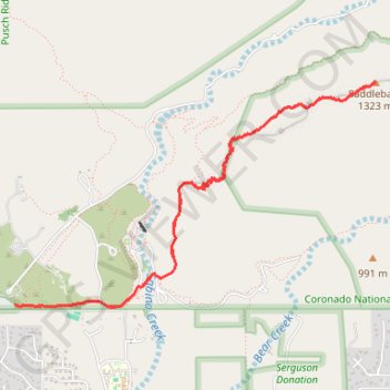
- Distance: 9.1 Km
- Elevation gain: 578 m
- Maximum elevation: 1,334 m
- Elevation loss: 577 m
- Minimum elevation: 816 m
Interactive trail map
Trail profile
- Distance: 9.1 Km
- Elevation gain: 578 m
- Maximum elevation: 1,334 m
- Elevation loss: 577 m
- Minimum elevation: 816 m
About this trail
Name: Saddleback via Phoneline Trail and Blackett's Ridge Trail in Pusch Ridge Wilderness trail, distance, elevation, map, profile, GPS track
Start: Esperero Trail #25, Pima County, Arizona, 85750, United States (32.30926 -110.82034)
End: Bear Canyon Trail #29, Pima County, Arizona, 85750, United States (32.30939 -110.82212)
Coordinates: 32.30917 -110.82212 32.32526 -110.79155
Other hiking, mountain biking, running and outdoor activity trails
Click on a trail to view its statistics, map and profile.
Seven Falls via Bear Canyon Trail in Pusch Ridge Wilderness
United States > Arizona > Pima County
The Bear Canyon Trail to Seven Falls offers hikers a captivating journey through the Sonoran Desert's diverse landscapes. Along the path alongside Bear Creek, you'll encounter towering saguaros stand sentinel amidst a variety of cacti, navigate through rocky terrains and ascend gentle inclines, all leading to…
Distance: 11.3 Km • Elevation gain: 348 m • Maximum elevation: 1,049 m