Make a donation
Gear up for your next adventure:
As an Amazon Associate, this site earns from qualifying purchases at no extra cost to you.
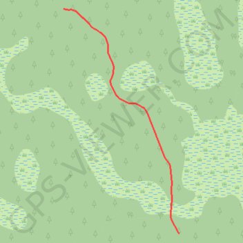
Little Tortoise Trail
- Distance: 1.0 Km
- Elevation gain: 1 m
- Maximum elevation: 10 m
- Elevation loss: 2 m
- Minimum elevation: 8 m
Interactive trail map
Make a donation
Gear up for your next adventure:
As an Amazon Associate, this site earns from qualifying purchases at no extra cost to you.
Trail profile
- Distance: 1.0 Km
- Elevation gain: 1 m
- Maximum elevation: 10 m
- Elevation loss: 2 m
- Minimum elevation: 8 m
Make a donation
Gear up for your next adventure:
As an Amazon Associate, this site earns from qualifying purchases at no extra cost to you.
About this trail
Name: Little Tortoise Trail trail, distance, elevation, map, profile, GPS track
Start: Tortoise Trail, Martin County, Florida, 34593, United States (27.20250 -80.37927)
End: Little Tortoise Trail, Martin County, Florida, 34593, United States (27.19505 -80.37498)
Coordinates: 27.19505 -80.37927 27.20250 -80.37498
Make a donation
Gear up for your next adventure:
As an Amazon Associate, this site earns from qualifying purchases at no extra cost to you.
Other hiking, mountain biking, running and outdoor activity trails
Click on a trail to view its statistics, map and profile.
Tortoise Trail
United States > Florida > Martin County
Distance: 2.6 Km • Elevation gain: 3 m • Maximum elevation: 10 m