Thank you for supporting this site ❤️
Make a donation
Make a donation
Gear up for your next adventure:
As an Amazon Associate, this site earns from qualifying purchases at no extra cost to you.
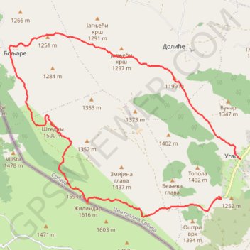
Pešter: Žilindar (1616m), Štedim (1500m)
- Distance: 19.0 Km
- Elevation gain: 687 m
- Maximum elevation: 1,611 m
- Elevation loss: 752 m
- Minimum elevation: 1,164 m
Interactive trail map
Thank you for supporting this site ❤️
Make a donation
Make a donation
Gear up for your next adventure:
As an Amazon Associate, this site earns from qualifying purchases at no extra cost to you.
Trail profile
- Distance: 19.0 Km
- Elevation gain: 687 m
- Maximum elevation: 1,611 m
- Elevation loss: 752 m
- Minimum elevation: 1,164 m
Thank you for supporting this site ❤️
Make a donation
Make a donation
Gear up for your next adventure:
As an Amazon Associate, this site earns from qualifying purchases at no extra cost to you.
About this trail
Name: Pešter: Žilindar (1616m), Štedim (1500m) trail, distance, elevation, map, profile, GPS track
Coordinates: 43.03917 19.98763 43.08137 20.06012
Thank you for supporting this site ❤️
Make a donation
Make a donation
Gear up for your next adventure:
As an Amazon Associate, this site earns from qualifying purchases at no extra cost to you.
Other hiking, mountain biking, running and outdoor activity trails
Click on a trail to view its statistics, map and profile.
2022_Yu
Slovenia > Ajdovščina > Žapuže
Distance: 2,457.3 Km • Elevation gain: 32,048 m • Maximum elevation: 1,950 m