Import a GPX file

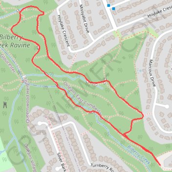
Bilberry Creek Ravine Loop

#Hiking #Snowshoeing #Running #Loop

  • Distance: 1.9 Km
  • Elevation gain: 13 m
  • Maximum elevation: 88 m
  • Elevation loss: 13 m
  • Minimum elevation: 80 m

Interactive trail map

Trail profile

  • Distance: 1.9 Km
  • Elevation gain: 13 m
  • Maximum elevation: 88 m
  • Elevation loss: 13 m
  • Minimum elevation: 80 m
👉 Easily get elevation data in JSON, GeoTIFF and KML formats using Elevation API
Thank you for supporting this site ❤️
Make a donation

Gear up for your next adventure:

As an Amazon Associate, this site earns from qualifying purchases at no extra cost to you.

About this trail

Other hiking, mountain biking, running and outdoor activity trails

Click on a trail to view its statistics, map and profile.

Ottawa - Grenville-sur-la-Rouge

Canada > Ontario > (Old) Ottawa

Ottawa River. #Bike #Ottawa #GrenvilleSurLaRouge

Distance: 93.5 Km • Elevation gain: 330 m • Maximum elevation: 73 m

Québec - Montréal - Saint-Laurent River - Lake Ontario - Niagara Falls

Canada > Quebec > Urban agglomeration of Québec > Quebec

#Bike #Ontario

Distance: 1,078.4 Km • Elevation gain: 4,804 m • Maximum elevation: 209 m

Ottawa - East Hawkesbury

Canada > Ontario > (Old) Ottawa

#Bike #Ottawa

Distance: 110.2 Km • Elevation gain: 221 m • Maximum elevation: 86 m

Gear up for your next adventure:

🍴Titanium Spork & Cutlery - Indestructible and feather-light eating utensils
🎒Dry Bags - Waterproof bags for outdoor gear
🎨Portable Watercolor Kits - Paint the landscapes and topographic views you discover
🎽Base Layers - Thermal base layers
🔭Compact Hiking Binoculars - Lightweight optics for scouting routes or birdwatching

As an Amazon Associate, this site earns from qualifying purchases at no extra cost to you.