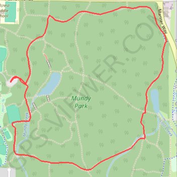
Import a GPX file

Mundy Park Loop

#Hiking #Running #Loop

  • Distance: 4.4 Km
  • Elevation gain: 98 m
  • Maximum elevation: 193 m
  • Elevation loss: 98 m
  • Minimum elevation: 152 m

Interactive trail map

Trail profile

  • Distance: 4.4 Km
  • Elevation gain: 98 m
  • Maximum elevation: 193 m
  • Elevation loss: 98 m
  • Minimum elevation: 152 m

About this trail

Other hiking, mountain biking, running and outdoor activity trails

Click on a trail to view its statistics, map and profile.

Vancouver - Golden

Canada > British Columbia > Metro Vancouver Regional District > Vancouver

#Bike #Vancouver #Golden

Distance: 827.6 Km • Elevation gain: 9,376 m • Maximum elevation: 1,347 m

Gear up for your next adventure:

🔑Heavy Duty Carabiners - Secure gear to the outside of your pack for easy access
🚴Bike GPS - GPS devices for cycling
🆘Personal Locator Beacons (PLB) - Satellite emergency beacons for life-saving help in areas with no mobile coverage
🥶Thermal Beanies - Warm hats for cold hikes
🔌Fast Charging Adapters - Quickly top up all your gear before heading back into the field

As an Amazon Associate, this site earns from qualifying purchases at no extra cost to you.