Make a donation
Gear up for your next adventure:
As an Amazon Associate, this site earns from qualifying purchases at no extra cost to you.
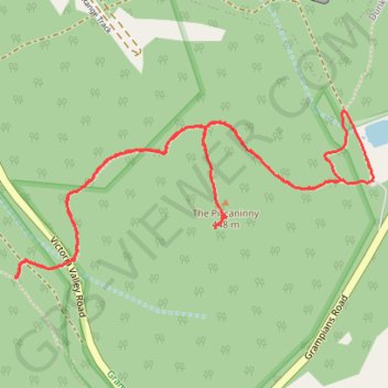
The Piccaninny
- Distance: 5.6 Km
- Elevation gain: 253 m
- Maximum elevation: 411 m
- Elevation loss: 252 m
- Minimum elevation: 262 m
- Moving time: 1 h 31 m
- Moving speed: 3.7 Km/h
- Maximum speed: 7.0 Km/h
- Total time: 1 h 49 m
- Global speed: 3.1 Km/h
Interactive trail map
Make a donation
Gear up for your next adventure:
As an Amazon Associate, this site earns from qualifying purchases at no extra cost to you.
Trail profile
- Distance: 5.6 Km
- Elevation gain: 253 m
- Maximum elevation: 411 m
- Elevation loss: 252 m
- Minimum elevation: 262 m
- Moving time: 1 h 31 m
- Moving speed: 3.7 Km/h
- Maximum speed: 7.0 Km/h
- Total time: 1 h 49 m
- Global speed: 3.1 Km/h
Make a donation
Gear up for your next adventure:
As an Amazon Associate, this site earns from qualifying purchases at no extra cost to you.
About this trail
Name: The Piccaninny trail, distance, elevation, map, profile, GPS track
Coordinates: -37.62240 142.32633 -37.61638 142.34254
Topography: Victoria topographic map, elevation, terrain
Make a donation
Gear up for your next adventure:
As an Amazon Associate, this site earns from qualifying purchases at no extra cost to you.
Other hiking, mountain biking, running and outdoor activity trails
Click on a trail to view its statistics, map and profile.
Cassidy Gap, Signal Peak, Mount Abrupt
Australia > Victoria > Dunkeld
Distance: 17.9 Km • Elevation gain: 906 m • Maximum elevation: 811 m
Dunkeld Mount Sturgeon Loop in Grampians National Park
Australia > Victoria > Dunkeld
Distance: 13.4 Km • Elevation gain: 485 m • Maximum elevation: 568 m