Ochre Falls
- Distance: 4.8 Km
- Elevation gain: 229 m
- Maximum elevation: 514 m
- Elevation loss: 257 m
- Minimum elevation: 278 m
- Moving time: 1 h 49 m
- Moving speed: 2.6 Km/h
- Maximum speed: 17.7 Km/h
- Total time: 2 h 24 m
- Global speed: 2.0 Km/h
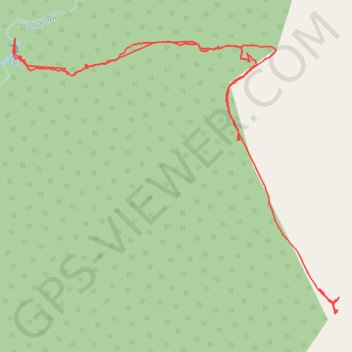
Interactive trail map
Trail profile
- Distance: 4.8 Km
- Elevation gain: 229 m
- Maximum elevation: 514 m
- Elevation loss: 257 m
- Minimum elevation: 278 m
- Moving time: 1 h 49 m
- Moving speed: 2.6 Km/h
- Maximum speed: 17.7 Km/h
- Total time: 2 h 24 m
- Global speed: 2.0 Km/h
About this trail
Name: Ochre Falls trail, distance, elevation, map, profile, GPS track
Start: Bella Creek Road, Lake Borumba, Gympie Regional, Queensland, Australia (-26.53142 152.48369)
End: Lake Borumba, Gympie Regional, Queensland, Australia (-26.52524 152.47991)
Coordinates: -26.53145 152.47084 -26.52158 152.48386
Topography: Queensland topographic map, elevation, terrain
Other hiking, mountain biking, running and outdoor activity trails
Click on a trail to view its statistics, map and profile.
Imbil Jimna Kenilworth loop
Australia > Queensland > Tewantin
Distance: 216.0 Km • Elevation gain: 3,884 m • Maximum elevation: 822 m