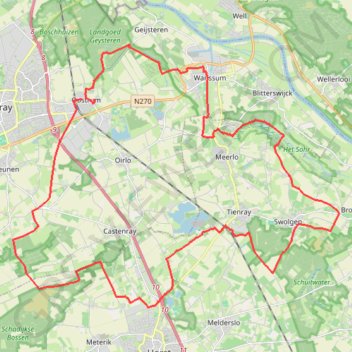
28-01-2024-gravel met Marion
- Distance: 40.9 Km
- Elevation gain: 78 m
- Maximum elevation: 30 m
- Elevation loss: 74 m
- Minimum elevation: 14 m
Interactive trail map
Trail profile
- Distance: 40.9 Km
- Elevation gain: 78 m
- Maximum elevation: 30 m
- Elevation loss: 74 m
- Minimum elevation: 14 m
About this trail
Name: 28-01-2024-gravel met Marion trail, distance, elevation, map, profile, GPS track
Start: 11, De Horik, Oostrum, Venray, Limburg, Netherlands, 5807 CJ, Netherlands (51.52911 6.02234)
Coordinates: 51.46608 5.98291 51.54571 6.14151
Other hiking, mountain biking, running and outdoor activity trails
Click on a trail to view its statistics, map and profile.
Meerdal-44-km-bij-america
Netherlands > Limburg > America
Distance: 44.0 Km • Elevation gain: 56 m • Maximum elevation: 35 m
Eurovelo 15 - Strasbourg Rotterdam
France > Grand Est > Bas-Rhin > Strasbourg
Distance: 891.7 Km • Elevation gain: 2,104 m • Maximum elevation: 146 m